Friday 12th October 2007 Fly/railway track Camp near Tozeur, Tunisia
Right next to three mosques with the loudspeakers calling prayers for the last day of Ramadan, Nev took a whole sleeping tablet and didn't hear the mosques waking up the Muslem men (who had partied until 2am) early in the morning for prayers. Anyway, we left early before he blew a fuse and drove to Matmata.
At Matmata the terrain is very eroded and lends itself to the local Berbers making their houses underground. They call them "troglodytes" which sounds very prehistoric, but they live very in the 21st century with satellite dishes, cell phones and a BMW parked in the entrance.
The houses are built with an entrance tunnel into an open-air courtyard. Off the courtyard several rooms have been dug into the cliff made by the courtyard. It is neat and painted white inside with a little pit toilet, kitchen, water drainage out the tunnel, and a little room for everyone. As it doesn't rain much (no rain for 5 years) all the dongas have been dammed with meter high wall to catch the soil and moisture. The hard work involved in building these walls bears fruit in the way of dates but mainly olives.
We then traveled further inland across the Great salt sea (Chott de Djarid), which is 2m above sea level and at least 50Km long and nearly as wide. The road travels straight through the middle to Tozeur and Nefta where there are millions and millions of well-farmed, neat date palms groves.
We found a secluded campsite in the desert among the tilted, salty sandstone hills which had been under the sea at some stage as there we sea shells and mineral deposits near a railway line.
Thursday 11th October 2007 Gapes, Tunisia
Two things which we also noticed about Libya is that the seashore has virtually no marine life (crabs, sea snails, sea urchins etc) except sea weed, and there is very little fishing activity on or off the shore. There are fish for sale occasionally, but very meager compared with the activity in SA.
Saleem nearly ran out of copies of the itinerary papers which he had to hand in on a regular basis at police check points.
We arrived at the border and had no trouble exiting Libya because Saleem did everything. We got a transit visa for Tunisia at the border with no problems and it only cost R100 for both.
Of course, just over every border the nature of the country is different again. Tunisia is poorer nation than Libya and the main means of transport is "skadonk" old cars, mopeds and bicycles. Donkey carts are again in evidence (none in Libya). There is a huge industry of smuggling petrol from Libya into Tunisia. All along the road for the first 200Km there are no petrol stations, but hundreds of spagpags, 20l, 10l, and 5l full of petrol for sale along the road. We don't know the price of fuel here, but we believe it is R6/l compared to Libya's 75c/l. At the check points the police were confiscating tins of oil and searching for excess petrol in the Tunisian vehicles.
They ignored us totally and we proceeded unhindered in Tunisia for a change, although there are check points every 40Km or so.
The countryside was only suitable for camels, goats and sheep and there were thousands of Ha of well-farmed olive trees sparsely spaced about 25mX20m apart. Many stores on the side of the road sell brightly decorated ceramic containers and fresh produce invitingly displayed.
We passed Bedouins who live in grass huts and general population live in poorer housing than in Libya.
We kept looking in vain for a book shop for info and a map of Tunisia, but it is the last day of Ramadan today and the shops are closed early and will be until Monday for Eid. But we are camping in a campground with other people for the first time since Khartoum, and they have given us information about where to go and what to see.
Map of Africa
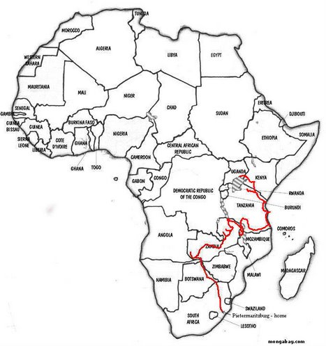
Our route
Subscribe to:
Post Comments (Atom)
No comments:
Post a Comment